
When you can’t run from the typhoon…
Two days ago, the U.S. military pre-positioned ships off Saipan heaved anchor and sailed to parts unknown. It’s commonly said on the island that when that happens, one should pay attention, as either there’s a conflict developing somewhere in the world or there’s bad weather brewing.

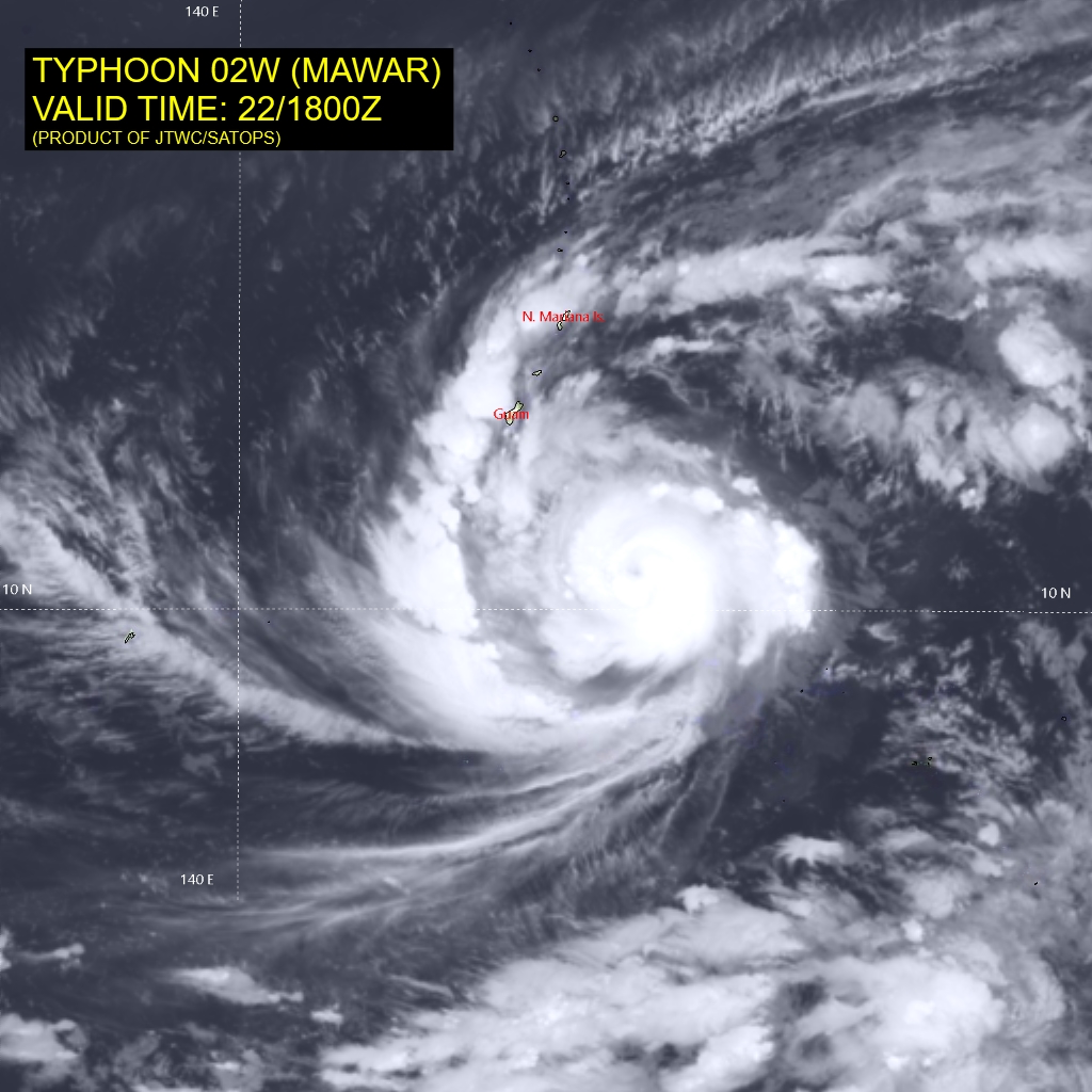
On this particular day, their sailing was not unexpected, as a disturbance Southeast of Guam and the Northern Marianas Islands was expected to develop into an organized system and, possibly, a typhoon. The local news had started talking about this disturbance a couple of days prior and it had been confirmed via online sources. Some of those sources – namely the U.S. Navy’s Joint Typhoon Warning Center and RSMC Tokyo – Typhoon Center are linked below.
Normally, a seafarer is on a ship and when hazardous weather is forecast, the vessel’s voyage plan is amended to avoid this area. In the case of tropical cyclones, NOAA formerly recommended the 1-2-3 Rule. this involved plotting the 34-knot wind radii from the text forecasts and then adding 100nm to the 24-hour forecast, 200nm to the 48-hour forecast and 300nm to the 72-hour forecast to account for inaccuracies in the forecast location. Creating a cone using these forecast circles, the mariner would then have an area to avoid.

This 1-2-3 Rule can still be used, but with increasing forecast accuracy, may be unnecessarily conservative. Updates to this rule have been suggested, with one recommending adding 60nm for each 24-hour interval to the 34-knot wind radii. The latest guidance in the Mariner’s Tropical Cyclone Guide from May 2023 (linked below) suggests simply avoiding the area of forecasted 34-knot winds with the 34-Knot Rule. Examples a National Hurricane Center’s Tropical Storm Force Wind Speed Probabilities demonstrates how this rule could be used, while the following example from the Joint Typhoon Warning Center does the same. Becoming familiar with the forecast products you might be using is critical to keeping you, your crew and your vessel out of danger.


But what happens when you aren’t on a ship and can’t maneuver your way to safety? What happens when you are on an island in the Northwest Pacific and find a super typhoon bearing down on you? Proper preparation might include downloading FEMA’s Emergency Supply List and obtaining these items BEFORE the storm arrives and preferably before your tropical storm season starts. Protecting your home or residence by covering windows to protect them from flying debris and securing loose items will help keep you and your neighbors safe.
Lastly, as with any quality management system, check that your actions are appropriate by implementing the Plan-Do-Check-Act (PDCA) cycle. This includes monitoring the track of the storm and modifying yours, your family’s and colleagues’ actions so as to best stay safe. It’s also an opportunity to pass along some of that seafaring knowledge that might help others best track and prepare for heavy weather.

Additional Reading and Links
Naval Oceanography Portal – Joint Typhoon Warning Center